CUH works with Google Earth on new development for Hawaii
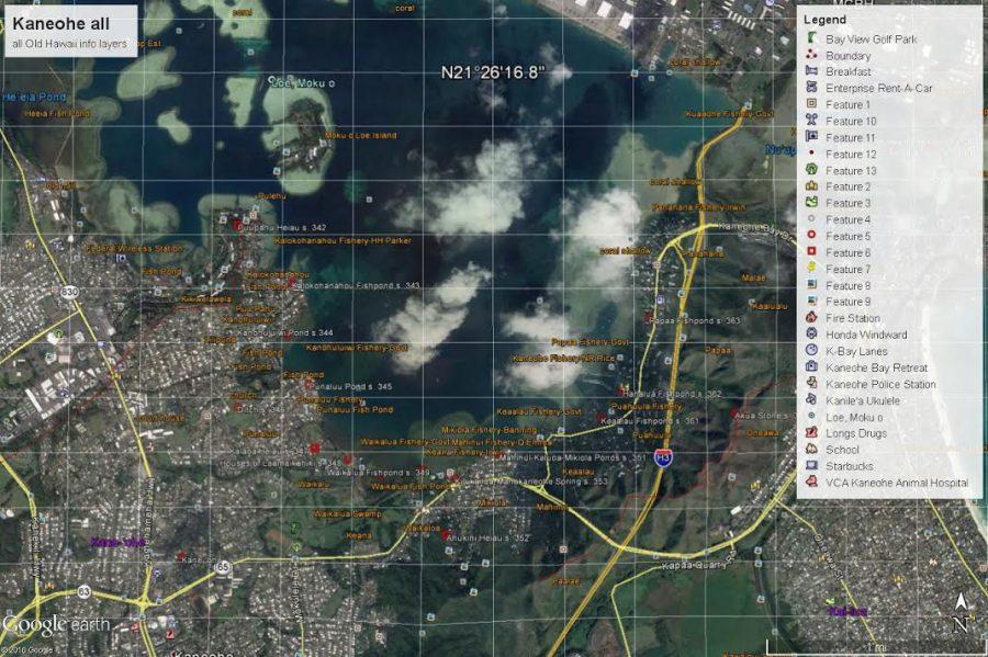
A view of Kaneohe, Oahu on Google Earth with some historical information layered in.
Hawaii is a chain of islands rich in history. Books, museums and kupuna (elder) keep account of the past and preserve it for future generations. Now, technology is helping the cause.
Google Earth is bringing Hawaiian history into the interactive digital world in what is being called the Google Earth Hawaii project.
This development will “place Hawaiian places names, Hawaiian areas, Hawaiian images, Hawaiian values onto the contemporary landscape,” Chaminade professor of Anthropology and Google Earth Hawaii creator Dr. Richard Bordner said.
For example, a user could be standing in Kaneohe, Oahu, open the Google Earth application on their smartphone and peel back the historical layers of that area. They would find information such as ancient names of specific places within Kaneohe, stories, myths or other historical content. It would be like having a live history book in the palm of your hand, linking the past to the present.
“You can see it on the landscape,” Bordner said. “That makes stuff a lot more real. It’s not something that is an abstract and in print.”
Alongside Bordner, Candice Sakuda, Chaminade’s director of Service Learning, is second in charge of this project. It started when Chaminade and Bordner were given a license to publish to Google Earth for a similar project for China. Google gave Chaminade free versions of Google Earth Pro and platforms to publish to, which is fairly uncommon.
Sakuda was talking to Bordner one day and was wondering if they could do the same project for Hawaii. However, Sakuda wanted it to be more about the stories and history of places around the islands rather than the archeological content.
Bordner then asked Google if Chaminade could do a spin-off of the China project for Hawaii and it agreed. This enterprise has now been in the works since 2013.
Chaminade students are the main enterers and gatherers of data, but anyone interested, Chaminade student or the public, can volunteer with this project.
At this time, all the information is being gathered from already published material and old maps. Books such as “Sites of Oahu” by Elspeth P. Sterling and Catherine C. Summers and old firefighter maps of Honolulu are being used as starting points.
With the immense amount of history and stories to input into the system, the Google Earth Hawaii project will be a continuous development. Bordner hopes that every month or every semester, Google Earth will be updated with the newest completed work.
However, it is still in discussion how contemporary the information inputted should get. It would be fascinating to see history entered from times such as the 1950s until now, but that may be too much compared to the 1,000 years of various information already shared.
The overall hope for this project is to preserve Hawaiian history and to make it easier to access. There are hundreds of books, maps and historical material at Bishop Museum and the state archives, but it is difficult to go though and to access. By putting it into an interactive digital format, it makes for more widespread, easier to access knowledge.
Google Earth Hawaii may also lend a hand in the world of construction. Through Google Earth, contractors, corporations and activists could use it to see if there was any historical or cultural significance on that piece of proposed land.
Knowledge is power, and with more knowledge, it may lead to the preservation of Hawaiian land.
Unfortunately, the Google Earth Hawaii project is almost at a standstill. With only two Chaminade students participating in the entering and gathering of information this semester, it is moving slower than hoped.
If you would like to participate to keep progress moving forward or volunteer for a service learning project, please contact Bordner at [email protected].